
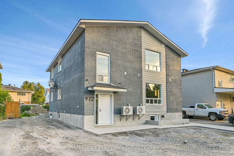
1-972 Dynes Rd
Carleton Square, Ottawa, Ontario K2C 0G8
- Bedrooms
- 1
- Bathrooms
- 1
- Size
- < 700sq ft
- Lot
- 53 x 100 ft
- Parking
- 2detached
- Days on market
- Members
The brief
About 1-972 Dynes Rd
1-972 Dynes Rd is a 1-bedroom, 1-bathroom multiplex in Carleton Square, Ottawa, listed for rent at an asking rent of $1,699 a month (MLS® X13721852).
Welcome to 972 Dynes Road. Be the first to live in these beautifully renovated 1 bedroom units! Enjoy a large kitchen with full size stainless steel appliances and in unit laundry. Each unit has separate heating and air conditioning controls so you can adjust the temperature to your liking at any time! Hardwood flooring and quartz countertops elevate the rental experience. Parking available upon request. The location is perfect - great for Carleton students as you are close to campus. Bus routes are convenient as well as walking and biking with many paths and the Experimental Farm near by. All prospective renters must submit: a Rental Application, Credit Report, Proof of Employment, Last 3 Paystubs, Government issued photo I.D. Tenant pays heat/hydro/renters insurance. Landlord pays water/snow removal.
Insights
Condition Score
Good73/1001 documented update signal
Source: Listing age, structured features and disclosed update language; not an inspection.
Condition uses listing-record signals, not an inspection.
The home
Key facts
- MLS® number
- X13721852
- Board
- TRREB MLS®
- Property Type
- Multiplex
- Days on market
- Size
- < 700 sqft
- Lot Size
- 53 x 100 ft
- Listed on
- Parking
- Detached, 2 Parking
- Lease terms
- 1 Year
Property details
Property
- Property Type
- Multiplex
- Style
- Apartment
- Community
- Carleton Square
- Municipality
- Ottawa
Building
- Size
- < 700 sqft
- Construction
- Brick
Inside
- Bedrooms
- 1
- Bathrooms
- 1
- Bathroom Details
- 1 × 4pc
- Basement Type
- None
- Kitchens
- 1
Parking
- Garage Type
- Detached
- Additional Parking
- 2
- Total Parking
- 2
Utilities
- Water
- Municipal
- Cooling
- Wall Unit
- Heating Type
- Baseboard
Land
- Sewer
- Sewers
- Frontage
- 53 ft
- Depth
- 100 ft
- Lot Size
- 53 x 100 ft
Additional
- Foundation
- Poured Concrete
- Roof
- Shingles
- Fireplace
- No
- Pool
- None
- Den
- No
- Family room
- No
- Extras
- Refrigerator, Stove, Hood fan, Dishwasher, Washer/Dryer combo.
Rooms
Room details unavailable
The listing source did not provide room-level measurements or features.
Listing history
Buy/sell history for 1-972 Dynes Rd, Ottawa, Ontario
Sale history on this site covers the last 2 years, the window permitted under the TRREB MLS® VOW agreement.
Dates and closing prices are shown to signed-in members.
| Date Start | Date End | List Price | Price | Event | Listing ID |
|---|---|---|---|---|---|
| Date Start— | — | $1,699 | — | Pc | X13721852 |
Members see the full history. Prices are hidden from signed-out visitors.
The numbers
Mortgage tools
Mortgage tools apply to sale listings.
Estimate
Estimated value requires sign in
Market estimates use sold comparables and are available after you sign in and accept MLS® VOW terms.
The estimate is an automated value built from public and MLS® data. It is not an appraisal; ask The Campbell-Maric Group for a full comparative market analysis.
Comparable leases
Comparable sales require sign in
Closing prices and sold comps are available to registered visitors who accept MLS® VOW terms on this site.
The land
Lot
- Lot area
- 5,300 sq ft492 m²
- Street frontage
- 53 ft16.2 m
- Depth
- 100 ft30.5 m
The area is the frontage multiplied by the depth, so boundaries are approximate. Confirm with a survey before you buy.
Source: the MLS® listing record, measured by MPAC.
Land and environment
Public records about this location. Not part of the MLS® listing and not provided by the listing brokerage.
Water and conservation6
- Not in Rideau Valley Conservation Authority’s mapped regulated areaChecked at the listing’s mapped point, not across the whole lot.At the address
- Not in the municipality’s mapped flood areaChecked at the listing’s mapped point, not across the whole lot.At the address
- No mapped wetland within 120 m120 m
- 1 water-supply well recorded within 250 m2 test or monitoring holes also recorded. From Ontario’s well records; locations can be approximate. The records do not show how this home gets its water. Wells nearby typically go down about 32.2 m.250 m
- Groundwater recorded about 6.9 m below ground nearbyThe middle water level in the well records within 500 m (31 records). It changes with the season and from spot to spot.500 m
- Bedrock about 24.4 m down nearbyThe middle depth to bedrock in the well records within 500 m.500 m
Rideau Valley Conservation Authority · Municipal flood mapping · Province of Ontario open data
Planning and building activity3
- Outside the Greenbelt, Oak Ridges Moraine and Niagara Escarpment plan areasChecked at the listing’s mapped point, not across the whole lot.At the address
- 4 building permits issued within 250 m in the last 2 yearsCreating 4 new homes.250 m
- Nearest airport: 3.9 km3.9 km
Province of Ontario open data · Municipal building permits
Around the home2
- Transit stop within 400 mFrom the transit agency’s published stop map; the nearest is 300 m away. Routes and stops change; check the agency’s schedule.400 m
- A trail or path within 1 km1 km
Municipal transit open data · Provincial and municipal trail maps
Environmental records4
- No licensed pit or quarry within 2 km2 km
- No recorded oil, gas or salt well within 250 m250 m
- No facility within 1 km reports pollutant releases to Environment CanadaThe nearest is Public Works and Government Services Canada — Confederation Heights Central Heating and Cooling Plant, 2.1 km away. Only facilities above the inventory’s reporting thresholds are listed.1 km
- 2 federal contaminated sites within 1 km1 still active or suspected; the rest are closed. The federal inventory covers federal land only, not provincial or private sites.1 km
Province of Ontario open data · Government of Canada open data
Power and internet3
- Electricity is distributed here by Hydro Ottawa LimitedAt the address
- Wired internet 50/10 Mbps or faster is listed at a household 50 m awayFixed wireless 50/10 Mbps or faster. LTE mobile coverage listed. ISED’s National Broadband Data at the nearest household point (50 m from the listing); 50/10 Mbps is its top category and includes faster plans. Confirm with a provider for this address.50 m
- Across the surrounding area: fibre to the home, cable, DSL internet listedFibre to the home: Bell, Rogers. Cable: Rogers. DSL: Bell. Fixed wireless: Bell, OmniTEC Wireless, PioneerWireless, Rogers, Storm Internet. Mobile: Bell, Rogers, Telus, Vidéotron. Satellite: Xplore. ISED’s list for the surrounding ~25 km² area; check with a provider for this address.Area-wide
Ontario Energy Board · Innovation, Science and Economic Development Canada
Each record is placed at the distance its own line states. None of it is an inspection of the property. Confirm anything that matters to you with the municipality, Rideau Valley Conservation Authority or the record’s publisher.
Contains information licensed under the Open Government Licence – Canada. Contains information licensed under the Open Government Licence – City of Ottawa. Contains information licensed under the Open Government Licence – Ontario.
The market
Market area · filters apply to the charts below
The street
Transit nearby
| Station | Lines | Distance |
|---|---|---|
| Mooney's Bay | OC Transpo light rail: O-Train Line 2 | 2.1 km |
| Carleton | OC Transpo light rail: O-Train Line 2 | 2.1 km |
| Heron | OC Transpo bus rapid transit: Transitway | 2.5 km |
| Billings Bridge | OC Transpo bus rapid transit: Transitway | 3 km |
| Walkley | OC Transpo light rail: O-Train Line 2 | 3.2 km |
The nearest subway, light rail, train, bus rapid transit stations 5 km, as the crow flies. Source: OC Transpo schedule data (GTFS) from the City of Ottawa under the Open Government Licence – City of Ottawa, downloaded October 18, 2026. Contains information licensed under the Open Government Licence – City of Ottawa.
Schools nearby
| Elementary | Type | Distance | EQAO average 2024–25 |
|---|---|---|---|
| St Augustine Elementary SchoolOttawa Catholic School Board | Catholic · grades JK–6 · French Immersion | 300 m | 82%Grade 6 average |
| St Rita Elementary SchoolOttawa Catholic School Board | Catholic · grades JK–6 · French Immersion | 1 km | 82%Grade 6 average |
| Carleton Heights Public SchoolOttawa-Carleton DSB | Public · grades JK–6 · French Immersion | 1.1 km | 46%Grade 6 average |
| École élémentaire catholique Laurier-CarrièreConseil des écoles catholiques du Centre-Est | French-language Catholic · grades JK–6 | 1.8 km | 79%Grade 6 average |
| Secondary | Type | Distance | Grade 9 math 2024–25 |
|---|---|---|---|
| St Pius X High SchoolOttawa Catholic School Board | Catholic · grades 9–12 · French Immersion | 500 m | 53%Grade 9 math |
| Brookfield High SchoolOttawa-Carleton DSB | Public · grades 9–12 · French Immersion | 1.9 km | 32%Grade 9 math |
| École secondaire publique Omer-DeslauriersConseil des écoles publiques de l'Est de l'Ontario | French-language public · grades 9–12 | 2.2 km | 38%Grade 9 math |
| Elizabeth Wyn Wood Secondary AlternateOttawa-Carleton DSB | Public · grades 9–12 · French Immersion | 2.8 km | — |
EQAO: share of students at or above the provincial standard, 2024–25 (Ontario open data). These are the schools nearest this home, not the schools it is assigned to: boundaries change, and some schools take students by application. Confirm with the board before you buy. Contains information licensed under the Open Government Licence – Ontario.
The verdict
Similar Active Listings
Recently sold nearby
Sold prices in Carleton Square are shown to signed-in members.